This proposal is not written to point fingers.
It is not here to publicly shame any government agency, humiliate any official, or assign blame for the state of Metro Manila's public transportation. That is not the purpose — and it has never been the purpose since this began in 2019.
What this is, plainly, is a call for discussion. A call for timeliness in the executive rulings and orders that concern public transportation. A call to take seriously what every Filipino commuter already lives — the daily reality of a city that moves millions of people on systems that have not fundamentally changed since the 1980s.
There are no political colors here. No drama. No agenda beyond this: we can do better, and we should start now.
Metro Manila's commuters are not a statistic. They are students getting to school, workers supporting families, entrepreneurs building things, teachers crossing the city to educate the next generation. They deserve a system that respects their time and their dignity.
“Filipino love for this city — and for the 14 million people moving through it every single day — is the only agenda behind every page of this proposal.”
This document is for research and advocacy purposes only. It is not affiliated with any government agency, transport authority, or political group. All routes and corridors are proposals subject to revision based on commuter demand, road conditions, and further technical study.
This network belongs to Metro Manila — and Metro Manila will always have the final say.
Contents
Metro Manila's roads were built for cars.
Its people aren't.
Car travel accounts for just 30% of person-km traveled in Metro Manila — but it takes up 72% of road traffic. A single bus moves 80–150 people in the space of 2–3 cars. The math works against the majority of road users every single day.
The bus system today was structured by LTFRB rules written in 1987. Routes exist because an operator found them profitable — not because a planner found them necessary. There is no network. There is no map. There is no single authority accountable for the whole.
Metro Manila ranked worst in global traffic in 2023, per the TomTom Traffic Index — beating 386 cities across 55 countries.[4]
Metro Manila's roads are allocated upside-down.
The pyramid shows the modes that carry the most people at the top — rail, then buses. At the narrowest tip: the pedestrian.
Today, Metro Manila allocates its roads in reverse. Private vehicles occupy the vast majority of road width. Rail and bus, the top two tiers, are squeezed into what remains.
MBT does not propose eliminating private vehicles. It proposes correcting the allocation — giving the highest-capacity modes the road priority they need to actually function at capacity.
One BRT lane moves more people than four car lanes.
Routes are built for operators.
Not for commuters.
The Land Transportation Franchising and Regulatory Board was established in 1987 — when Metro Manila still had large undeveloped areas. Its model made sense then: operators propose routes, government approves or denies.
That logic no longer holds. Today, all 636 km² of Metro Manila is fully built-out — and actively expanding. The Manila Bay reclamation projects, the construction of the New Manila International Airport (NMIA) in Bulacan, and new expressway corridors within and adjacent to the metro will bring additional trip demand into an already saturated road network. MBT does not compete with these investments — it provides the internal distribution network that makes large-scale infrastructure useful to the daily commuter.
Yet the LTFRB framework hasn't changed. Routes still exist because an operator found them profitable — not because a planner found them necessary.
There is no network map. No unified card. No single authority accountable for the whole.
The EDSA Carousel is Line 1.
It already works.
The EDSA Busway, launched in June 2020, is live proof of MBT's core argument. When buses are given a dedicated median lane, separated from mixed traffic, with proper boarding stations — they work. Travel times drop. Ridership climbs.
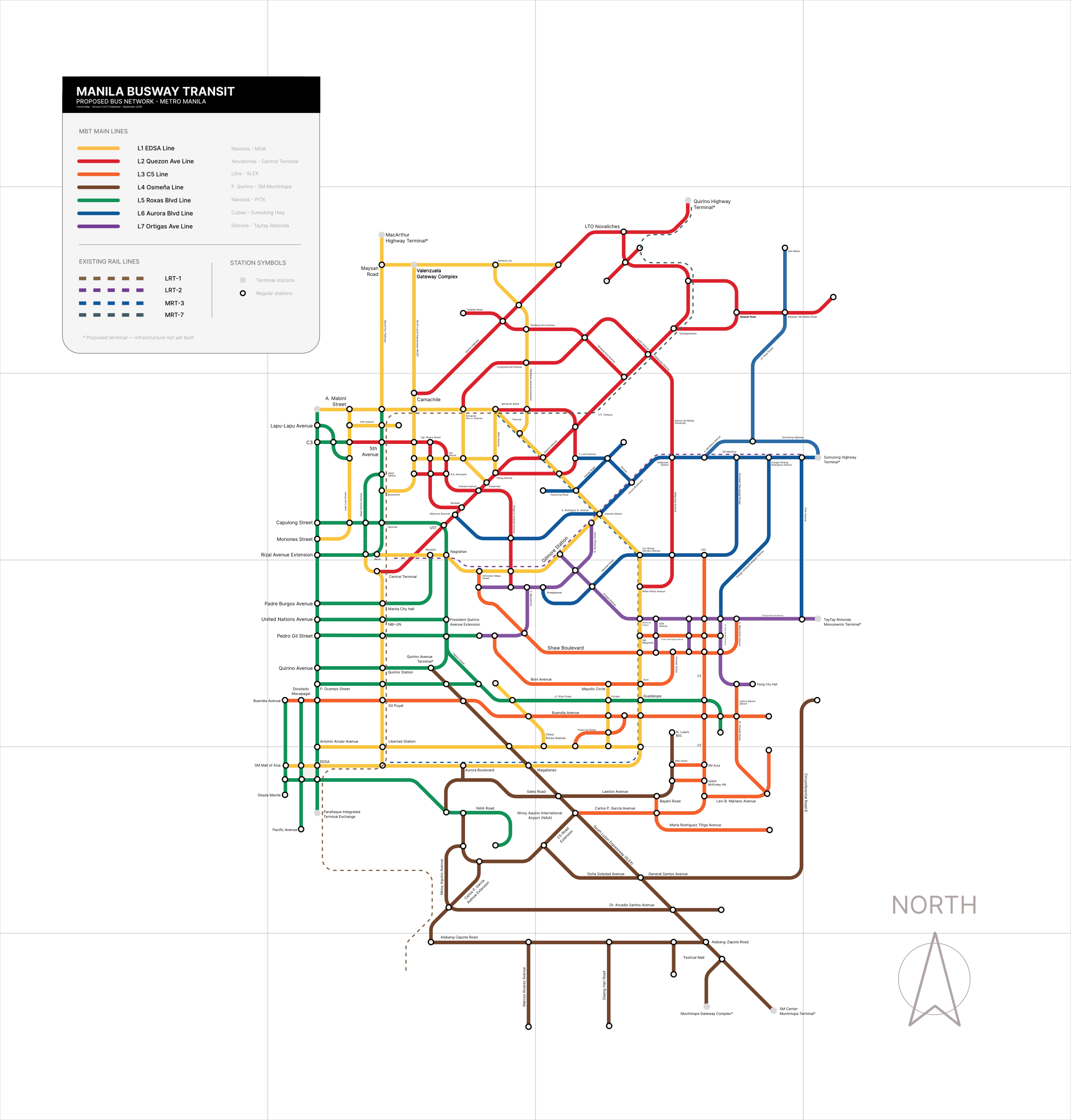
MBT's Yellow Line (L1) closely mirrors the existing Carousel with two key differences: the terminus shifts to Navotas Terminal in the north and SM Mall of Asia in the south — both more logical anchors — and a refined stop list that eliminates redundant loading points.
BRT is not experimental in Manila. It is already operating. The question is why only one of seven corridors has been built.
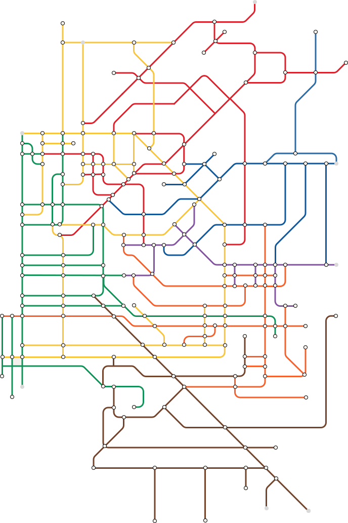
Seven corridors. One network.
Each BRT main line occupies one dedicated median lane — physically separated from mixed traffic, operating 24 hours, 7 days a week.
If building a subway takes a generation, we need a solution that works in this one.
Bus Rapid Transit is not a compromise. BRT mirrors railway logic exactly — median stations, dedicated lanes, high-capacity buses. Cities like Bogotá, Curitiba, Jakarta, and Bangkok have proven it delivers rail-level capacity on roads that already exist. Manila already proved it on EDSA.
“The question is not whether BRT works in Manila. The EDSA Carousel answered that in June 2020. The question is when the other six corridors follow.”
Network maps.
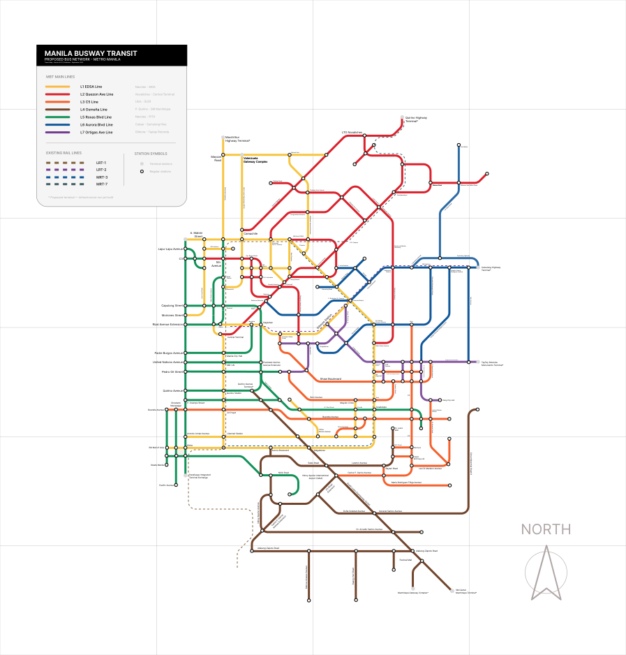
Two maps cover the MBT network — the detailed transit map showing all corridors, stops, and feeder routes; and the visual overview map for a high-level read.
The traditional jeepney does not belong on EDSA, C5, or Roxas Boulevard. It was never designed for highways — mixing it with buses and trucks at speed is where the safety and congestion issues come from.
Remove it from those roads — not by banning it, but by giving those roads to BRT — and the jeepney finds its natural home: the barangay streets, the narrow collectors, the last-mile corridors where no articulated bus can go.
The jeepney is one of the most recognizable symbols of Filipino identity. The hand-painted murals, the chrome horses, the names of saints along the side — a living folk art tradition born from repurposed WWII vehicles.
The so-called e-jeepney is a different vehicle entirely — closer to a mini-bus. What the traditional jeepney needs is proper enforcement, safety standards, and route rationalization. Not replacement.
Metro Manila's roads are as creative as its people. There are streets in Cubao, Tondo, and Sampaloc where no articulated bus will ever fit. The jeepney was made for those streets. Let it work there — celebrated and properly routed — while BRT handles everything it was never suited for.
Provincial buses stop at the gate.
MBT takes it from there.
If MBT's internal network is strong enough, provincial buses no longer need to fight Manila traffic. They stop at a gateway terminal. MBT handles the rest. Eight gateways intercept buses at the Metro Manila boundary — covering every major provincial approach road.
* Proposed terminal. Location and infrastructure subject to planning.
These are my thoughts. Not the proposal's — mine.
We have been acting like it is the first time. We are not.
Metro Manila is not the first city to face this problem. Cities around the world have already solved it, or are in the process of solving it. What frustrates me is that we keep acting as if there is no roadmap to follow. There is. We are late, but as the saying goes — it is better late than never.
We are actually in the right position to make good decisions. The data exists. The case studies exist. Other cities have already made the mistakes so we do not have to.
I do not use public transportation. And that is exactly the problem.
I will be upfront: I have been working from home ever since. I do not ride public transit daily. But I want to be honest about why — because I think it is the same reason millions of Filipinos opt for private vehicles instead.
The system was not built for them. Car-centric policy did not just fill the roads with cars — it made public transportation so unreliable that choosing it feels like a sacrifice, not a commute.
Every Filipino I know who has been to Taipei, Singapore, or Hong Kong has taken the train. Not because they had no choice — but because it worked well enough that they never even thought about driving.
From 2019 to now — what are the answers, and do they work?
I ask this genuinely, not as an attack. The NSCR is on its way. The subway ROW issue has been resolved. The North Triangle Common Station — I heard a consortium has been completed. These are real moves and I acknowledge them.
But for the daily commuter in 2026, the question is still the same: does it work yet? MBT is not a replacement for the subway or the railway. It is a complement — something that can be built and running while the bigger infrastructure takes shape over the next decade.
I would have stopped if the numbers were decreasing. They are not.
The number of people affected keeps growing. Every time I visit another city and see a functioning transit system, I am reminded of how achievable this actually is. The answer is not complicated: build more subways, build more trains. And if that future arrives — if Metro Manila one day has a complete rail network — then Manila Busway Transit may no longer be necessary.
I have made peace with that. The goal was never MBT. The goal was always the commuter.
October 25,
2019.
A 19-year-old from Balintawak, Quezon City sat down and started writing. There was no institution behind it, no grant, no title. There wasn't even a name for what this was yet.
The first paper covered a single corridor — EDSA, from Andres Bonifacio Shrine in Caloocan to the Mall of Asia in Pasay. It was called “Bus Transit System” at first. Then “Metro Busway Transit.” The acronym MBT was born early and never left.
In June 2020, the EDSA Busway launched — a dedicated median lane, proper boarding stations, one operator per route. The Yellow Line concept, written in 2019, was now operating.
The network grew from there. What started as one line became seven main BRT corridors, each with underlying feeder routes reaching into the barangays. By 2025–2026, the full name sharpened: Metro became Manila. Same three letters. More precise home.
This proposal is a starting point, not a final answer.
All routes, corridors, and line designations are proposals subject to revision. Routes may be added, modified, or removed depending on actual commuter demand, road conditions, right-of-way constraints, and the evolving needs of Metro Manila's residents.
This plan was built from observation, research, and citizen-level analysis — not from engineering surveys or official feasibility studies. Any actual implementation would require rigorous technical study, public consultation, and formal planning processes.
The commuter is at the center of this proposal. If the data says a route should move, it moves. If the people say a corridor is missing, it gets added. This network belongs to Metro Manila — and Metro Manila will always have the final say.